October 2025 Volume 23 Issue 10
|
We are a voice for our small town, grassroots members who may otherwise not have access to the right audiences, as well as a conduit for industry to come together in support and promotion of transportation improvements.
We are committed to working as an Alliance to improve transportation infrastructure and business networks opportunities, by advocating for appropriate funding levels, so business and industry can thrive.
We are focused on the economic and business interests that are the lifeblood of the region.
|
Be Sure Newsletter Email is Allowed
|
As you may have noticed, the monthly Ports-to-Plains Newsletter is sent through our member database. Please be sure the email address pal@memberclicks-mail.net is allowed on your system.
|
This week I am making a presentation on the role that interstates play in providing resiliency during natural disasters and other events that could disrupt transportation services. This presentation is part of a larger discussion moderated by Breanna Horne from STV, Inc. looking at the importance of planning for resilience in all of our transportation modes, including mass transit. Resiliency planning is an important component of future interstate systems as we continue to work to justify the purpose and need for considerable investments in our nation’s infrastructure. From the beginning, interstates were designed to provide reliable access to resources in a reasonable amount of time. It does not matter if we are talking about the delivery of food, energy, or the deployment of our military assets. Imagine if you can, a transportation system with no interstates. Then imagine that system trying to evacuate people away from the coast or better yet, Houston during a hurricane event. Or try to imagine a rain cell dumping so much rain in your part of the world, that every road in and out of your community is underwater. Without an interstate highway, food and other services to your community could be disrupted for extended periods of time.
Our interstate system today is designed in a way to mitigate the impacts of natural disasters. Roadbeds are elevated, pavement structures are strengthened, low water crossings are replaced with bridge structures, and multi-lanes are provided to increase reliability when trying to get food and fuel to population centers, or people out of population centers. But even so, our interstates are functioning on a 50-year-old design. So how will tomorrow’s interstates be built to mitigate all the potential risks that could disrupt the movement of goods and people across our nation. And what kind of disruptions are we talking about if it is not hurricanes, floods, and fires and earthquakes.
|
In all our conversations we talk about the need to improve our corridor because it will assist our nation with all kinds of securities, food security, energy security, cybersecurity, and trade security, you name it. Security from what? Being able to live in a country or on a continent that can be self-sustaining and provide food and energy independence will reduce the probability of disruptions or having resources being held hostage from countries not aligned with American priorities. This could include potential threats on food and energy producing centers within our country. We tend to forget the real threats that events like 911 had on our nation’s infrastructure until it is too late and we are reacting again to another like event. As recently as this last summer, efforts to smuggle an agroterrorism weapon into the US were thwarted, preventing potential devasting impacts to several main crops grown in the mid-western US. We also know that a known component of any military strategy is economic destabilization. When we lose the ability to control our energy and food resources, our risk of having our economy compromised by foreign influences rises.
So how does building a future interstate through the heartland of the United States help us with these potential threats. I already mentioned that interstate design standards will raise the bar when it comes to mitigating natural disasters. In addition to the resiliency provided, alternate routes will be provided through some rural areas of the United States which will keep commerce and freight moving to destinations that otherwise would not have that access. As for the other threats, the technology enhancements that would accompany a future interstate will help with items like border security, securing port activities, monitoring intrastate freight traffic, and improving access to better communication and information when managing the threats become eminent. This will add another reason to the why we need to build a future interstate corridor.
more to come …
Lauren D. Garduño
|
Membership Renewals Going Out in November
|
As over the past years, Renewal Invoices will be sent out in November. No changes in rates.
|
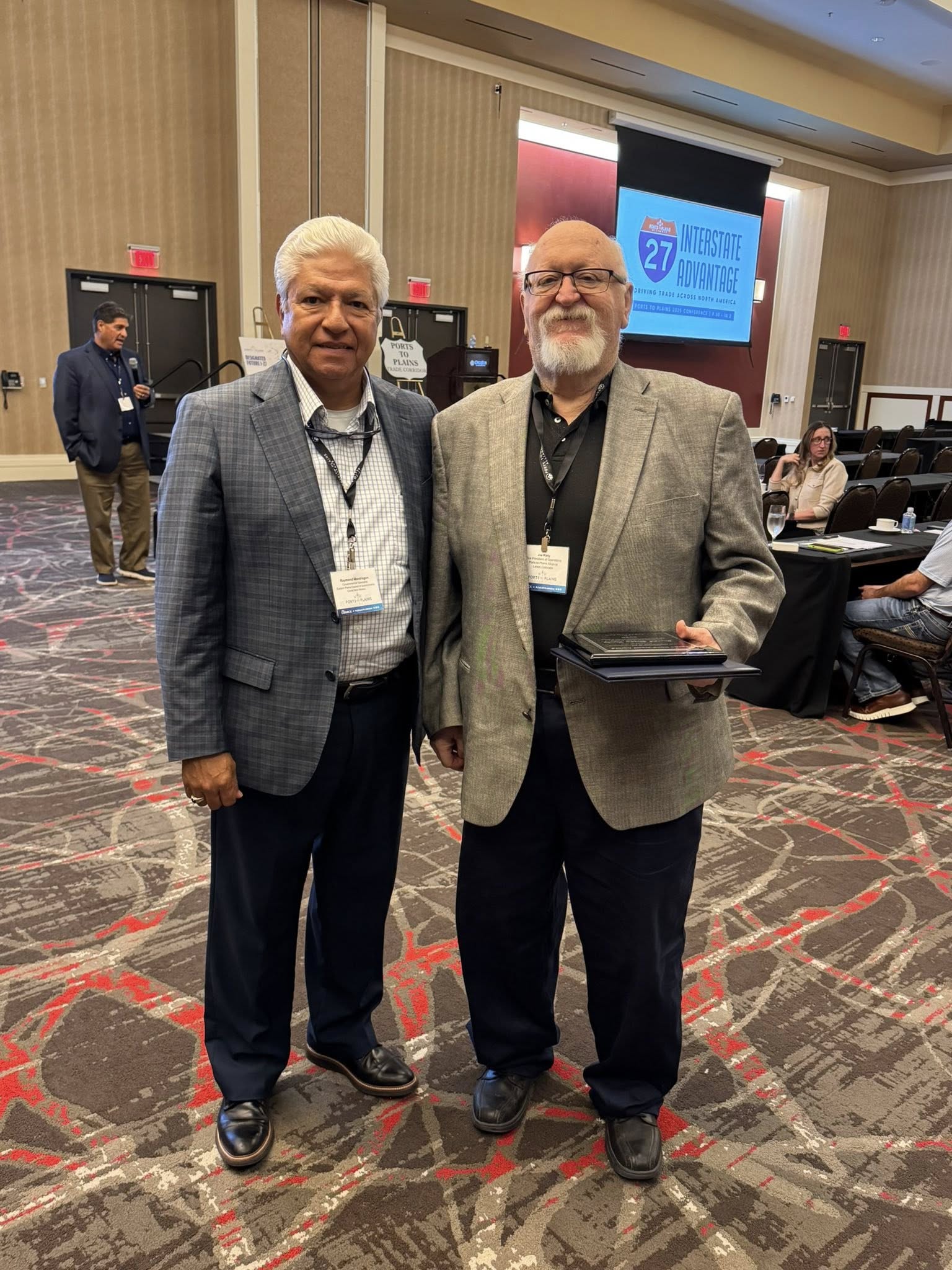
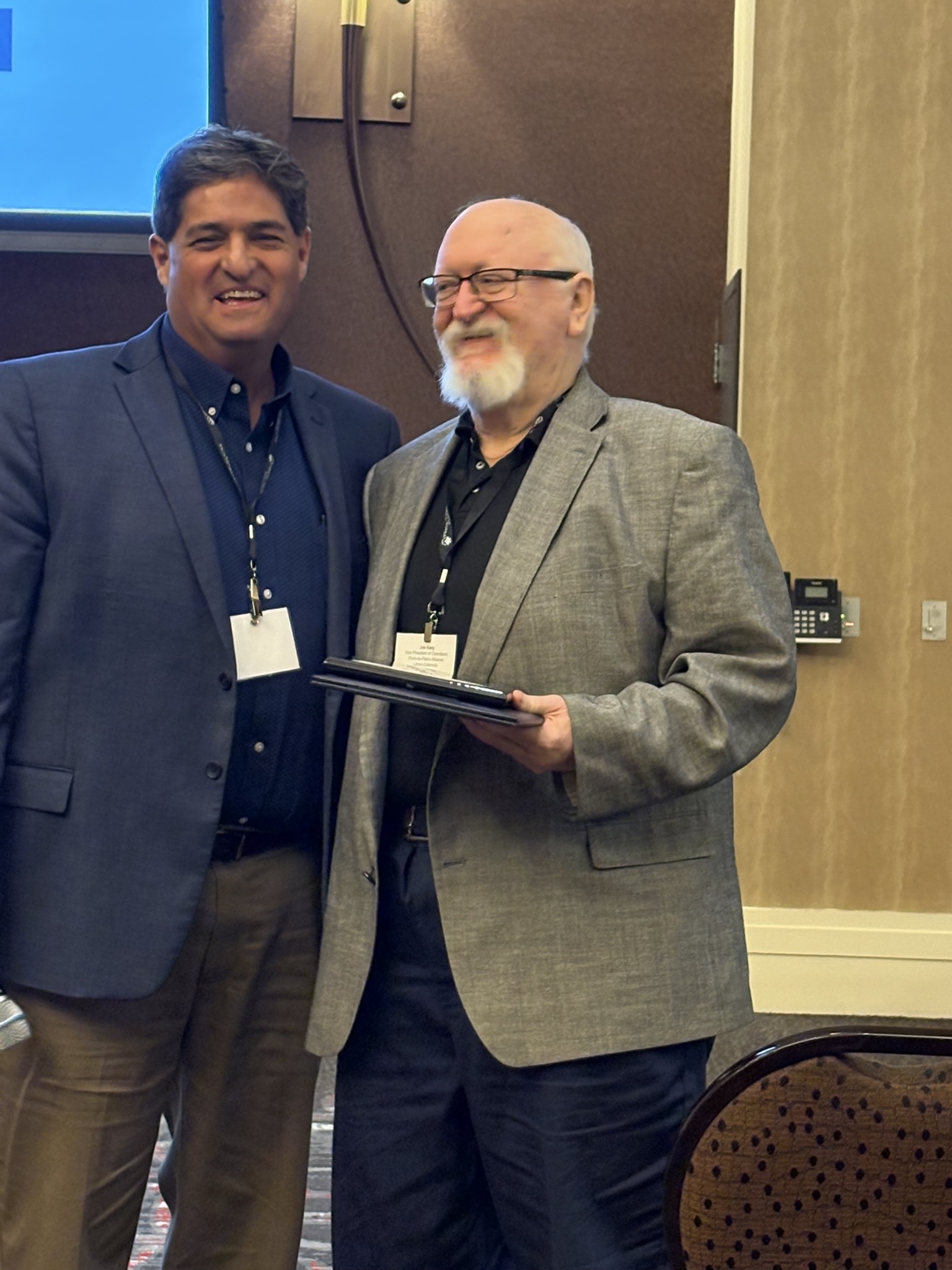
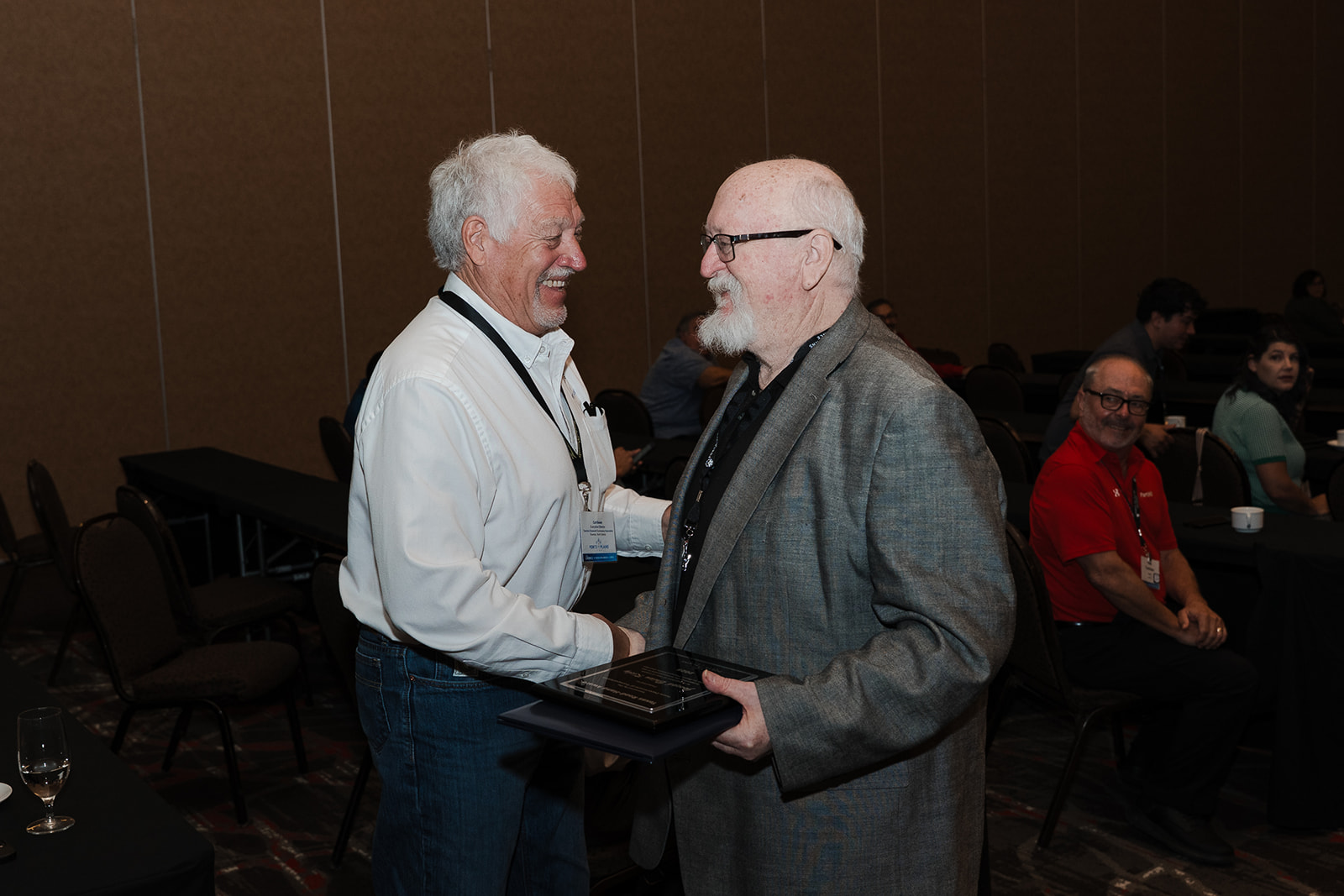
Joe Kiely Honored as Road Hand by the Texas Department of Transportation
|
Lubbock, Texas — October 2, 2025. Joe Kiely of Limon, Colorado, the current Vice President of Operations for the Ports-to-Plains Alliance, was honored as a Road Hand by the Texas Department of Transportation (TxDOT) during the 2025 Ports-to-Plains Alliance Conference held in Lubbock.
Created in 1973 by then-State Highway Engineer, Luther DeBerry, the Road Hand Award recognizes individuals who have “freely given their time, energy, support, and vision” toward improving transportation in Texas. It is one of the highest honors TxDOT can bestow upon a non-employee—citizens, community leaders, public officials, and advocates whose efforts have made a lasting difference in Texas transportation.
Kiely joins roughly 280 recipients over the past 52 years and is notably the first non-Texan ever to receive the award. The recognition was presented by Brian Barth, TxDOT’s Deputy Executive Director for Program Delivery, who praised Kiely’s 27 years of service advancing Texas transportation.
Barth highlighted Kiely’s key contributions to major statewide and regional initiatives, including the Texas Freight Plan, the Texas-Mexico Border Transportation Master Plan, the Ports-to-Plains Corridor Development and Management Plan, the Ports-to-Plains Interstate Feasibility Study, and the I-27 System in Texas Implementation Plan. Kiely also played an instrumental role in the Congressional designation of the Ports-to-Plains Corridor as a High Priority Corridor on the National Highway System and its subsequent designation as Future Interstate 27.
While serving the Town of Limon as minister at the Limon Church of Christ, Kiely represented Lincoln County and its municipalities on the inaugural Ports-to-Plains Alliance Board of Directors beginning in 1997. In 2020, he transitioned from the board to become the Vice President of Operations, a role he continues today. Under his leadership, the Alliance has grown from a four-state initiative to a nine-state corridor spanning from Mexico to Canada.
The official certificate presented to Kiely read:
“Joseph Kiely is a certified member of the Texas Road Gang, having proven ability and displayed stamina to toil long, strenuous hours for Texas transportation. And be it known that in recognition and appreciation of proven labor, the Texas Department of Transportation shall post your name on the indelible roll of honored and distinguished Road Hands.”
The certificate was signed by the Executive Director of TxDOT and the Texas Transportation Commission.
|
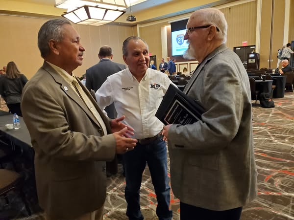
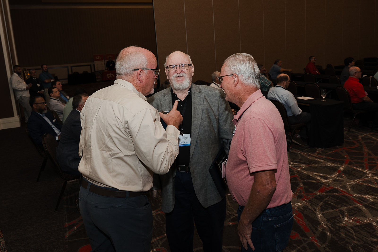
2025 Conference Follow-up
|
Video highlights of the 2025 Ports-to-Plains Alliance Conference
|
We appreciate the preparation and sharing of knowledge by the speakers and the hospitality of Lubbock, TX. Below you will find follow-up information for presentations, photos, videos, and sponsors. We had great feedback on Captain Chris Cassidy as the Keynote Address.
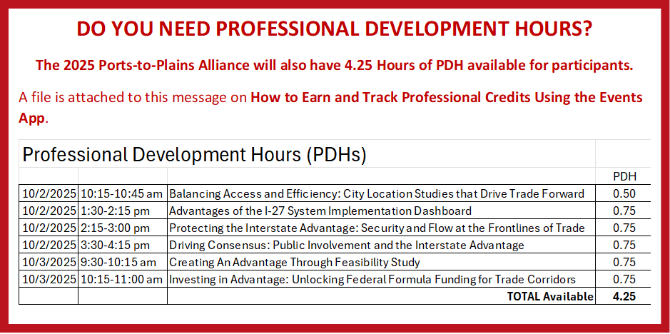
Professional Development Hours
We do apologize for the issues with the App for the Professional Development Hours. To make it worse, those of you that followed directions to use the paper log and leave it on the registration table also did not get credit because they were not picked up. We have two logs that were handed directly to Joe. If you have not received your PDH Certificates or have not yet submitted, Click HERE to Download PDH Logs. Please fill it out and send to Joe Kiely (joe.kiely@portstoplains.com) and he will send you certificates.
|
Value of Future Interstate Highway: Rich Flores, Chair, County Commissioners, Kimball County, NE
|
Kimball County is a small place with big purpose—where agriculture is our foundation, but our future is being shaped by innovation, resilience, and national service.
This is what delivering rural prosperity looks like.
|
Click on the image above to view Video
|
Bid Opening Set for Hwy 85 Widening
|
Four-Lane Project Part of Two Separate Bids November 7 and November 21, 2025
The North Dakota Department of Transportation is set to open bids in November on two critical segments of U.S. Highway 85, advancing a long-planned expansion to four lanes through the rugged Badlands region heavily used by oilfield traffic.
The projects, funded by a mix of state and federal dollars under Senate Bill 2012, total $155 million and span 19.5 miles south of the Long X Bridge to the junction with Highway 200. The first segment, from reference post 120 to the Long X Bridge, is already advertised and will see bids opened Nov. 7 in Bismarck. The second, from Highway 200 north to RP120 about eight miles north of Grassy Butte, is slated for advertisement soon, with bids due Nov. 21.
"It's one of the most expensive stretches along the entire corridor," said Cal Klewin, executive director of the Theodore Roosevelt Expressway Association, referencing the Badlands segment during an update to the Williams County Commission in August. He noted the terrain's challenges will demand two years of construction once contracts are awarded.
The expansion addresses safety concerns on the two-lane highway, which carries about 4,500 vehicles daily, including heavy oil rigs. Funding includes $55 million in state dollars matching a federal grant for the Highway 200-to-RP120 stretch, and $100 million in state funds for the southern portion. The work will build on the recently completed rebuild of the Long X Bridge and widening the stretch from there north to Watford City, part of a multi-phase push to four-lane the entire 62-mile corridor from Interstate 94 to Watford City by 2030.
Klewin highlighted the project's broader role in linking Texas to North Dakota's energy patch, boosting tourism to Theodore Roosevelt National Park and the forthcoming presidential library.
"We're pushing for a four-lane divided highway now, but the interstate designation is about future potential," he said, referring to efforts to brand the route as Interstate 27.
The association is rallying support for the upcoming Surface Transportation Bill renewal, seeking federal aid for planning and environmental studies to extend the four lanes south to the South Dakota border.
Bids will be evaluated for cost, timeline, and compliance, with awards expected shortly after openings. Officials say the upgrades will cut congestion, enhance passing zones and normalize speeds, while minimizing environmental impacts per a 2019 federal review.
Thanks to Western Dakota Energy Association WDEA
|
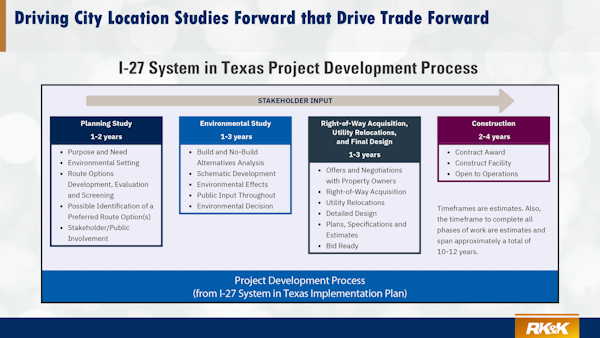
Balancing Access and Efficiency: City Location Studies that Drive Trade Forward
|
Terry McCoy, P.E., Transportation Advisor, RK&K
|
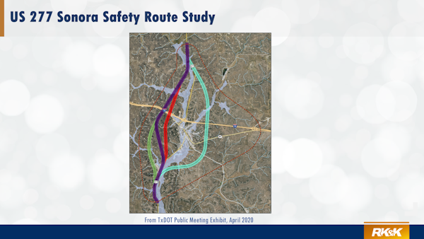
Once designated as a Future Interstate Highway, the first step in planning is a City Location Study. A City Location Study is a preliminary transportation planning and engineering study conducted to determine the best general location or corridor for a new segment of highway, or major transportation facility in or around a city or urbanized area.
“City Location Studies are recommended around communities or environmental features where upgrading the existing facility to interstate standards may not be feasible or reasonable. The City Location Studies are expected to yield project recommendations, which will potentially modify the future implementation of the interstate upgrade projects. District should prioritize conducting City Location Studies in the near-term (0-4 years), barring any local sensitivities.”
- From I-27 System in Texas Implementation Plan
|
PURPOSE OF A CITY LOCATION STUDY
- Identify and Compare Alternative Routes
-
- Evaluate multiple potential alignments for a new or improved highway, bypass, or connector around a city
- Determine which route best meets mobility, safety, environmental, and community objectives
- Support Early Decision-Making
-
- Provide data and analysis for city leaders, state DOTs, and the public to make an informed decision on which corridor to advance into environmental and design phases
- Establish a basis for formal project approval or inclusion in a state or metropolitan transportation plan
- Balance Competing Priorities
-
- Assess trade-offs among transportation efficiency, cost, environmental impacts, community effects, and future growth
- Help agencies avoid conflicts with existing development or sensitive environmental or cultural resources
- Define a Preferred Corridor or “Study Area”
-
- Narrow a broad area of interest into a single “preferred corridor” (often a few miles wide) that can later be refined into specific alignments during design
- Support submittal to the Federal Highway Administration (FHWA) for further study under NEPA (National Environmental Policy Act) if federal funding or approval is involved
|
WHAT QUESTIONS RISE TO THE TOP?
Property Owners:
- Loss of property
- Displacement
- Noise and air quality
- Visual impacts
- Bisecting property
- Access
- Property values
Business Interests:
- Reduced traffic/loss of revenue
- Too much traffic/loss of revenue
- New route development potential
Special Interests:
- Environmental (protected species, waters/wetlands, etc)
- Cultural resources (historic & archeological)
- Induced development
|
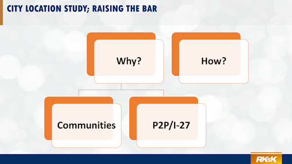
Why?
The answers to the Why question are straightforward.
Communities
First as we contemplate changing the way traffic moves in and around cities and purchasing ROW that may change lives, we owe a Gold Standard to every community and to every affected person represented on our map
P2P/I-27
Second, from talking to all the people who routinely work with these studies, this is how we best assure success, and we owe success to the P2P/I27 initiative
|
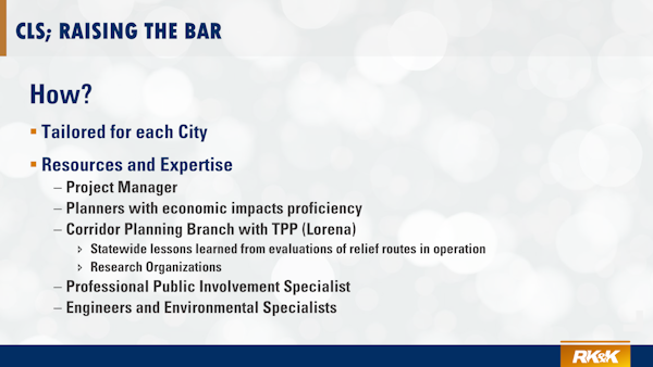
How?
It is fair to say that the greatest uncertainties we will face come from the Non-Engineering side of the Study and it may also be fair to say that how well we handle these challenges will determine whether a study is successful or not. This is really where we have struggled in the past and where we have the greatest opportunity to think bigger and work outside the traditional box.
- Coordination and Two-Way Communication
- Local project Champion and Steering Committee
- City Manager and Staff and Elected Officials
- Economic Development Corporation
- Potentially affected business owners
- Potentially affected property owners
- Community
- GOAL – Comprehensive Understanding of Local Issues, Concerns, and Suggestions
- GOAL – Transparency and Trust
- GOAL – Approval of CLS
- State DOT District and Regional Offices
- State DOT Planning Divisions
- Citizen Committee
- GOAL – Preservation of Corridor
- GOAL – Advance CLS into Schematic and Environmental Phase
|
I-27 has been identified by the Texas Transportation Corridor as a corridor of statewide significance in the 2050 Long Range Plan and all City Location Studies (CLS) (outside of MPO boundaries) have Plan Authority.
Each CLS may proceed as District funds allow.
“Projects outside of an MPO boundary, on a Corridor of Statewide Significance, and approved with PLAN Authority may proceed with environmental clearance based on the district’s budget availability to support the effort.”
Link to Complete Presentation
Link to City Location Study Report Template
|
Has Your Organization Considered these Resolutions? - Doing Something Big
|
The Ports-to-Plains Alliance has a unique opportunity to do Something Big for our corridor — strengthening the path to funding, construction, and economic growth for communities from Mexico to Canada.
You can download by CLICKING HERE and following the Links;
Three proposals are now before Congress that will:
- Fund Development and Construction of Future Interstates
- Establish a Multi-State Future Interstate Highway Formula Program to accelerate planning, design, and construction along designated Future Interstate Corridors
- Gather the Data to Drive Decisions
- Launch a Future Interstate Feasibility Study to evaluate the economic, safety, and mobility benefits of extending Future Interstate 27 across the remaining Ports-to-Plains Corridor and all of the Heartland Expressway and Theodore Roosevelt Expressway
- Show Unified Support for Future Interstate and I-27 Route Numbering
|
Joe Kiely
Vice President of Operations
Ports-to-Plains Alliance
PO Box 758
Limon, CO 80828
Cell: (719) 740-2240
joe.kiely@portstoplains.com
|
Cal Klewin
Executive Director
Theodore Roosevelt Expressway Association
PO Box 1306
Williston, ND 58802
701-523-6171
cal@trexpressway.com
|
Deb Cottier
Chair
Heartland Expressway Association
337 Main Street
Chadron, NE 69337
308-432-4023
dcottier@gpcom.net
|
|